North Sea Flood 1953
The flood of 1953 is the most devastating natural disaster recorded in the United Kingdom in the 20th Century. A severe north-westerly storm combined with a spring tide that caused large parts of Britain’s east coast to flood. In England 307 people did not survive the disaster, thousands of animals lost their lives and homes were also destroyed. In the Netherlands 1,836 people are reported to have died as dikes failed in 150 locations. ADA looks back at the disaster on its 65th anniversary.
Anatomy of a storm
A north-westerly storm developed on January 29, 1953, south of Iceland. On Friday 30 January, once it was clear that a severe storm was developing, the UK Meteorological Office issued its first weather warnings. However, the human impact was exacerbated by disruption to telephone and radio services, so that many of those affected received no warning, and were unaware of the scale of the disaster.
The storm crossed the North Sea just two days after the full Moon, interacting with the spring tides (when the gravitational pull of the Sun and Moon combines to create the highest tide of the lunar cycle). The storm continued southward through Scotland causing extensive damage, with 19 fatalities reported. The fishing village of Crovie, on the Moray Firth, was abandoned as entire structures were swept into the sea.
The surge then passed down the East Coast of England during the night of 31 January into the southern North Sea, where the surge effect was intensified as the coasts of eastern England and the Netherlands funnel together and the sea becomes shallower. The combination of wind, high tide, and low pressure resulted in water levels of more than 5.6 metres (18.4 ft) above mean sea level in some locations. This was over half a metre higher than had been recorded during the previous 80 years and for many sections of coast it remains the highest recorded surge in the North Sea.
Impact
The flood and waves overwhelmed sea defences and caused extensive flooding. The powerful surge and associated waves scoured the seaward face of the defences while water that had overtopped or flowed through cracks and permeable layers eroded the inland face, leading to damage and collapse. Elsewhere, sand and earth fillings were washed out, undermining the embankments and again leading to collapse.
Over 1,600 km of coastline was damaged, and sea walls/embankments were breached, inundating 650 km². In Lincolnshire, flooding occurred from Mablethorpe to Skegness, reaching as far as 3 km (2 miles) inland. Water flooded up to 8 km (4 miles) inland around Cley on the north Norfolk coast, and to a depth of 1.8 m (6 feet) in Kings Lynn.
It was not just coastal communities that were at risk, as the surge travelled inland from The Wash along the Rivers Great Ouse and Nene, causing both rivers to overflow and break their banks. Along the south bank of the River Thames defences were breached, and the floodwater reached the top of embankments in central London.
Flooding seriously damaged 24,000 properties, of which 500 were totally destroyed. Around 32,000 people were safely evacuated and around 200 industrial facilities were damaged by floodwater.
Recovery
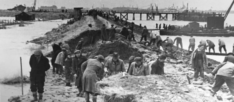
One of the UK’s largest peace time military operations was immediately mobilised to rescue inhabitants from the floodwaters, and to temporarily repair and stabilise the damaged defences. At the operations peak on 12 February 1953, 30,000 emergency workers were involved. The huge repair and recovery operation meant that around 90% of the breaches in England were closed within a month.
Responses
The catastrophe revealed the inadequacy of coastal defences then in place and led to Britain’s largest sea defence improvement program. In the following years, defences were raised by up to 2 m (6.5 feet) and strengthened around population centres. The fear of a major storm surge flood in London eventually led to the construction of the Thames Flood Barrier near Woolwich, which became operational in 1982.
The storm surge also led to the development of the Storm Tide Warning Service, a national flood-warning organisation, which was created to improve the accuracy and efficiency of coastal surge warnings to the public as well as the authorities. Today this is provided through the joint Environment Agency and Met Office partnership in flood forecasting.
In the Netherlands an extensive system of dams and storm surge barriers known as the Delta Works were developed. You can learn more about the Dutch commemoration on the Rijkswaterstaat 65th anniversary webpage and by our sister association the Dutch Union of Water Boards.
The improvements to coastal flood defences since 1953 have significantly reduced the risk of such a flood occurring again today. ADA’s members continue to manage, maintain and improve the essential flood risk management infrastructure along England’s east coast and associated river catchments. It is important not to forget important events of our past so that we properly value these services today and ensure that we adequately invest as a society in flood risk management for the future given the increasing risks from climate change, growing populations and economic development and aging infrastructure.
More information: many of the key facts and statistics about the 1953 North Sea flood can be read here in this Retrospective by RMS (Risk Management Solutions).
Categories
Archive
- July 2026
- May 2026
- April 2026
- February 2026
- January 2026
- December 2025
- November 2025
- October 2025
- July 2025
- June 2025
- March 2025
- February 2025
- January 2025
- December 2024
- November 2024
- October 2024
- September 2024
- August 2024
- July 2024
- June 2024
- May 2024
- April 2024
- March 2024
- January 2024
- December 2023
- November 2023
- October 2023
- September 2023
- August 2023
- July 2023
- June 2023
- May 2023
- April 2023
- March 2023
- February 2023
- January 2023
- December 2022
- September 2022
- August 2022
- July 2022
- June 2022
- May 2022
- April 2022
- March 2022
- February 2022
- January 2022
- December 2021
- November 2021
- September 2021
- July 2021
- May 2021
- March 2021
- February 2021
- January 2021
- December 2020
- November 2020
- October 2020
- September 2020
- August 2020
- July 2020
- May 2020
- April 2020
- March 2020
- February 2020
- January 2020
- December 2019
- November 2019
- October 2019
- September 2019
- August 2019
- July 2019
- June 2019
- May 2019
- April 2019
- March 2019
- February 2019
- January 2019
- December 2018
- November 2018
- October 2018
- September 2018
- August 2018
- July 2018
- June 2018
- May 2018
- April 2018
- March 2018
- February 2018
- January 2018
- December 2017
- November 2017
- October 2017
- September 2017
- August 2017
- July 2017
- June 2017
- May 2017
- April 2017
- March 2017
- February 2017
- January 2017
- October 2016
- September 2016
- August 2016
- July 2016
- June 2016
- May 2016
- April 2016
- March 2016
- January 2016