Asset resilience improvements across the Water Management Consortium
The four internal drainage boards of the Water Management Consortium cover a total area of 120,106 hectares across Lincolnshire and the lower Trent catchment.
Ten storms between September 2023 and January 2024 resulted in widespread flooding across the country. Heavy rainfall on an already saturated catchment put pressure on these Boards’ systems, particularly over the Christmas period where pumping stations ran continuously.
Following those events, the Consortium’s Boards have been successful in achieving funding for a number of catchment improvement projects as part of Tranche 2 of Defra’s IDB Storm Recovery & Asset Improvement Fund. The investment is addressing water level management challenges highlighted by these past intense rainfall events, improving the resilience of these catchments during high flow events.
Doncaster East IDB
Doncaster East IDB have completed two projects to reduce the frequency and severity of flooding by increasing the capacity within key watercourses that depend on the IDB’s pumping stations to discharge into the River Torne.
During periods of intense rainfall, the IDB’s system serving the Middle Drain (Tickhill) catchment of 210ha became overwhelmed, with limited storage causing flooding of high-grade arable land and encroaching towards isolated properties. The works to the Middle Drain outfall, Dadsley Well Stream, Wellingley Drain, and Middle Drain have significantly improved their capacity to manage stormwater, as well as reshaping these channels to create additional wetted habitat, contributing to a more diverse ecological environment.
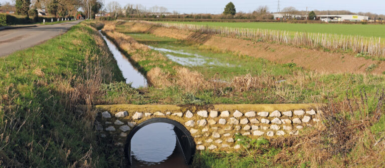
Elsewhere, on the outskirts of Doncaster, in the 450ha Kilham Farm to Candy Farm catchment, recent storm events had resulted in overtopping of the River Torne overwhelming two IDB pumping stations, with floodwater spreading across farmland and reaching the Environment Agency’s Candy Farm North Pumping Station. To address this, Doncaster East IDB has undertaken works to increase storage, improve maintainability, and manage flows between the three pumping stations. The scheme includes deepening, widening and desilting several lengths of South Ring Drain, along with upgrading the A614 road culvert to improve conveyance.
Trent Valley IDB
The Sutton and Carlton on Trent catchments cover 845 hectares of rural villages and agricultural land drained through gravity and pumped systems discharging into the River Trent. High outfall levels during recent storm events prevented the gravity system from operating, and limited in-catchment storage, contributing to flooding of farmland and properties.
Phase 1 of works to address the situation consisted of deepening and widening Bulham Lane Drain to increase storage capacity and improve conveyance. Phase 2 will shortly begin, involving the reforming of Carlton Cross Drain, Carlton Lane Feeder, Carlton Mill Drain, and Cuckstool Dyke.
Lindsey Marsh Internal Drainage Board
The Board’s Boygrift (2,800ha) and Anderby (3,590ha) catchments both discharge through pumping stations into the North Sea north of Skegness. The Huttoft Main Drain provides a hydraulic link between the two catchments. However, the bed levels and existing structures along this channel currently restrict the movement of water between the two catchments. With gravity discharge at Anderby Pumping Station performing well during low tide, improving Huttoft Main Drain will allow the Boygrift catchment to drain by gravity through Anderby and enable flood flows to be balanced between the two catchments.
Work is nearing completion on deepening, widening, and desilting 3,623 metres of Huttoft Main Drain. The next stage of the scheme is underway to remove and upgrade the existing road culvert and installing a new penstock to control water levels between two catchments.
Telemetry advancements
The Consortium are utilising technology advancements to create efficiency in the delivery of their role and ways of working. The Boards’ telemetry systems provide real time information on the status of all the Boards’ pumping stations, and they are an essential tool during both routine operations and storm events. Across the four IDBs, the installation of 39 gauging stations is being incorporated into the Boards’ existing telemetry systems.
The project involves fitting each site with a kiosk containing a telemetry unit and solar power system, and at selected locations, installing an automatic tipping rain gauge and a water level sensor positioned over the watercourse. This will help Duty Officers to remotely check and monitor water levels across the catchments, reducing staff time and travel, and supporting targeted work where required in a more efficient way.
Environment Benefits
The works that are being undertaken will support the diversity and enhancement of the ecological environment. Water voles are regularly recorded within many of these catchment areas, and the works will increase wetted habitat available to the protected species while improving overall catchment resilience. The Boards monitor both protected and invasive species, with over 1,200 records uploaded to local record centres during the past year.
 A huge thank you to all our team and our partners for their hard work, passion and commitment to achieve these important improvements.
By Megan Forman, Content Creator, Water Management Consortium – First published in the ADA Gazette, Spring 2026
For more information about Water Management Consortium, or to follow and support their work, visit their website at www.wmc-idbs.org.uk
Categories
Archive
- July 2026
- May 2026
- April 2026
- February 2026
- January 2026
- December 2025
- November 2025
- October 2025
- July 2025
- June 2025
- March 2025
- February 2025
- January 2025
- December 2024
- November 2024
- October 2024
- September 2024
- August 2024
- July 2024
- June 2024
- May 2024
- April 2024
- March 2024
- January 2024
- December 2023
- November 2023
- October 2023
- September 2023
- August 2023
- July 2023
- June 2023
- May 2023
- April 2023
- March 2023
- February 2023
- January 2023
- December 2022
- September 2022
- August 2022
- July 2022
- June 2022
- May 2022
- April 2022
- March 2022
- February 2022
- January 2022
- December 2021
- November 2021
- September 2021
- July 2021
- May 2021
- March 2021
- February 2021
- January 2021
- December 2020
- November 2020
- October 2020
- September 2020
- August 2020
- July 2020
- May 2020
- April 2020
- March 2020
- February 2020
- January 2020
- December 2019
- November 2019
- October 2019
- September 2019
- August 2019
- July 2019
- June 2019
- May 2019
- April 2019
- March 2019
- February 2019
- January 2019
- December 2018
- November 2018
- October 2018
- September 2018
- August 2018
- July 2018
- June 2018
- May 2018
- April 2018
- March 2018
- February 2018
- January 2018
- December 2017
- November 2017
- October 2017
- September 2017
- August 2017
- July 2017
- June 2017
- May 2017
- April 2017
- March 2017
- February 2017
- January 2017
- October 2016
- September 2016
- August 2016
- July 2016
- June 2016
- May 2016
- April 2016
- March 2016
- January 2016